

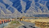

SALT LAKE CITY — Gov. Spencer Cox announced Tuesday the completion of the master plan map for the Utah Trail Network, a visionary system that will eventually include 3,100 miles of connected paved trails across the state.
The Utah Department of Transportation (UDOT) designated 2,600 miles of new trails and integrated 500 miles of existing paths into the network. Once complete, officials estimate that 95% of all Utahns will live within one mile of the trail system.
Cox made the announcement during the Utah Transportation Conference, stating the network will connect 208 towns, 33 universities, six national parks, and 25 state parks. He stated, “We need to spend more time outside, more time connecting with people and more time exercising, and the way we do that is through our trail system.”
The first round of funding for the Utah Trail Network involves a nearly $95 million investment across the state to build or plan 19 new paved trails, with several projects slated to begin construction next spring.
Of the 13 projects deemed "construction ready" in this inaugural round, several will focus on closing major gaps and connecting critical community hubs. One will take place in Cache Valley, where a $4 million investment will fund the Blacksmith Fork River Trail, a 1.8-mile trail connecting Ridgeline High School to the Blackhawk Soccer Complex and the existing Logan River Walk trail.
The project, championed by Cox in 2022, is funded through the Active Transportation Investment Fund, created by the Legislature in 2023. UDOT Executive Director Carlos Braceras hailed the plan as a moment Utah changes how it gets around. Earlier this year, the Utah Transportation Commission approved nearly $95 million to build and plan 19 new paved trails or complete existing gaps.
The Utah Transportation Commission approved this initial funding to prioritize projects that connect to public transit or important community amenities, furthering Governor Cox's vision for a connected, statewide transportation system.
(3) comments
Will the Trails allow Bikes and Ebikes?
Oh! Lookie lookie: https://utahtrailnetwork.udot.utah.gov/home
Maps? Is there a government website where one could visit for more information, like a map? Someone once said, a map is worth a thousand words of directions. You'd think an announcement like this would include some cartography. Perhaps the reporter who wrote this up could do a follow up and ask for some illustrations.
Welcome to the discussion.
Log In
Keep it Clean. Please avoid obscene, vulgar, lewd, racist or sexually-oriented language.
PLEASE TURN OFF YOUR CAPS LOCK.
Don't Threaten. Threats of harming another person will not be tolerated.
Be Truthful. Don't knowingly lie about anyone or anything.
Be Nice. No racism, sexism or any sort of -ism that is degrading to another person.
Be Proactive. Use the 'Report' link on each comment to let us know of abusive posts.
Share with Us. We'd love to hear eyewitness accounts, the history behind an article.